- Home Page /
- Office Products /
- Office & School Supplies /
- Education & Crafts /
- Geography Materials /
- Maps /
- National Geographic World Wall Map - Executiv...


Item #:
10454360
National Geographic World Wall Map - Executive - Laminated (46 x 30.5 in) (National Geographic Reference Map) Map Wall Map, January 1, 2020
Item #:
10454360
LKR 13708
Price Details
Excluding Shipping & Custom charges ( Shipping and custom charges will be calculated on checkout )
*All items will import from US
In stock
QTY:
Order now and get it around Wednesday, June 24
Secured transaction
Ubuy works hard to protect your security and privacy. Our advanced payment security system ensures confidentiality by encrypting your information during transmission using AES (Advanced Encryption Standards) and SSL (Secure Socket Layer) protocols. Your payment details are 100% secure as we do not share your payment details with third party sellers.
Our Top Logistics Partners
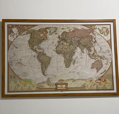
Expertly researched and designed, National Geographic's World Wall Map is the authoritative map of the world by which other reference maps are measured.
Fast
Shipping
Free
Return*
Secure Packaging
100% Original Products
PCI DSS Compliance

ISO 27001 Certified
Note: Step Down Voltage Transformer required for using electronics products of US store (110-120). Recommended power converters Buy Now.


What Stands Out
High-Quality Material
Crafted on durable, laminated paper, this map ensures long-lasting use while resisting wear and tear, making it ideal for educational settings, offices, or home decorations.
Detailed Design
Featuring an extensive level of detail with vibrant colors and geographic accuracy, this map helps users understand global geography while enhancing their spatial awareness and learning.
Large Size
Measuring 46 x 30.5 inches, this large wall map serves as a striking centerpiece, ideal for classrooms or offices, allowing for easy visibility and facilitating discussions around world geography.
Product Details
- Antique-style executive color palette with subtle shaded relief and labeled mountain ranges
- Clearly defined international boundaries, cities, islands, and physical features
- Up-to-date territorial control reflecting de facto status on the ground
- Meticulously researched using authoritative sources including U.N. and U.S. Board on Geographic Names
- Accurate place names using a combination of conventional English names and standard transliterations
- Encapsulated in heavy-duty laminate for durability and resistance to humidity
| Publisher | National Geographic Maps |
| Publication date | January 1, 2020 |
| Edition | 2020th |
| Language | English |
| Print length | 1 pages |
| ISBN-10 | 0792283252 |
| ISBN-13 | 978-0792283256 |
| Item Weight | 1.37 pounds (620 grams) |
| Dimensions | 1.97 x 31.18 x 1.97 inches (5 x 79.2 x 5 cm) |
Who Should Buy?

-
Educators
Perfect for teachers, this map enhances geography lessons and provides a visual tool for classroom discussions.
-
Office Spaces
Ideal for corporate offices, this map serves as an inspirational decoration while facilitating planning and discussions.
-
Travel Enthusiasts
Great for those who love to explore; it allows users to plan adventures and mark places they'd like to visit.

-
Budget Shoppers
This premium map may not fit the budget constraints of users seeking more economical home decor options.
-
Small Spaces
The large size (46 x 30.5 in) makes it unsuitable for users with limited wall space or smaller rooms.
-
Casual Users
People looking for a simple or basic map might find this detailed wall map overly complex for their needs.
Product Description
Have any Query? Chat with us
Customer Questions & Answers
-
Question:
What are the dimensions of the National Geographic Executive Wall Map?
Answer: The National Geographic Executive Wall Map measures 46 x 30.5 inches. This sizable format makes it an excellent choice for schools, offices, or home decor, providing a visually impactful representation of the world. The large size ensures that all geographical details are easily readable from a distance, enabling you to use this map for educational purposes, presentations, or simply to enhance your living space. -
Question:
Is this wall map laminated, and why is that important?
Answer: Yes, the National Geographic World Wall Map is laminated, which enhances its durability and makes it easy to clean. The lamination protects the map from everyday wear and tear, ensuring it maintains its vibrant colors and details over time. This feature is particularly beneficial for environments like classrooms or offices where the map may be referenced frequently, as it allows for easy wiping to remove marks or smudges. -
Question:
What type of information can I expect to find on this wall map?
Answer: The National Geographic Executive Wall Map provides detailed political and physical features of the world. You'll find countries, major cities, bodies of water, and significant geographical features like mountains and rivers. This comprehensive detail makes it an invaluable tool for educators, travelers, or anyone looking to enhance their geographical knowledge and awareness. -
Question:
Can this wall map be used for educational purposes?
Answer: Absolutely! The National Geographic World Wall Map is an excellent educational resource for teachers and students alike. Its detailed representation of the world makes it ideal for geography lessons, helping students visualize locations and political boundaries. Additionally, it can serve as a reference point for projects, discussions, and interactive learning activities, promoting an engaging classroom environment. -
Question:
What environments are suitable for displaying this wall map?
Answer: This wall map is versatile and can be displayed in various environments, including homes, schools, and offices. Its sophisticated design complements office decor, while its educational value makes it perfect for classrooms. Whether in a study, conference room, or nursery, this map enhances the aesthetic while providing a functional tool for geographical learning. -
Question:
How can I effectively hang this wall map?
Answer: To hang the National Geographic Executive Wall Map, using adhesive strips or hooks is recommended for a hassle-free and damage-free installation. Ensure the surface is clean and dry, and consider the map’s height for optimal viewing. This careful positioning will enhance its visibility, allowing everyone to enjoy its detailed representation of the world. -
Question:
Is this wall map suitable for framing?
Answer: Yes, the National Geographic Wall Map can be framed if you want to add a touch of elegance or additional protection. Framing enhances the visual appeal and allows you to match it with your room's decor. It also provides added durability and creates a finished look that can be a centerpiece in your office or home. -
Question:
What makes National Geographic maps stand out?
Answer: National Geographic maps are renowned for their accuracy, attention to detail, and artistry. The Executive Wall Map is backed by extensive research and geographical expertise, ensuring that it offers reliable information. The combination of aesthetic design and rich detail makes National Geographic maps not only functional but also beautiful decorative items. -
Question:
Can I find this map in different languages or editions?
Answer: While the National Geographic Executive Wall Map is predominantly available in English, select editions may include multilingual labels or alternative formats. Always check the product description to confirm the language options available for your specific edition, ensuring it meets your preference or requirement for language learning and cultural exploration. -
Question:
Where can I buy the National Geographic World Wall Map in Sri Lanka?
Answer: You can purchase the National Geographic World Wall Map - Executive - Laminated 46 x 30.5 in from Ubuy in Sri Lanka. Ubuy offers a convenient shopping experience, allowing you to easily find this detailed map and have it delivered to your doorstep, making it a perfect addition to your home or office décor.
Maps Editorial Review


The National Geographic World Wall Map is an ideal addition to any home or office, providing detailed geographical information in a beautifully illustrated format. Measuring at 73 x 48.5 inches, this map is perfect for display or as a functional tracking map with locator pins. The laminated finish ensures that the map can be used with dry erase markers for easy route planning. While the map is mostly up to date, it does not show Russia's recent annexation of Crimea. The colors are subtle and attractive, with a level of detail that includes small towns and smaller roads in addition to the big cities and freeways, making it perfect for planning road trips or travel routes. The terrain features also provide an understanding of significant inclines. While there were some concerns with shipping and laminating issues from previous customers, these complaints were not very common.
Customer Reviews & Ratings
711 customers ratings
-
5 Star
85%
-
4 Star
12%
-
3 Star
2%
-
2 Star
0%
-
1 Star
1%
Review this product
Share your thoughts with other customers
Pros
- Large size perfect for display or tracking
- Detailed and up-to-date geographical information
- Subtle and attractive colors
- Can be used with dry erase markers for easy route planning
- Terrain features provide an understanding of significant inclines
Cons
- Does not show Russia's recent annexation of Crimea
Product Price History
Important information
- Limitations : For products shipped internationally, please note that any manufacturer warranty may not be valid; manufacturer service options may not be available; product manuals, instructions, and safety warnings may not be in destination country languages; the products (and accompanying materials) may not be designed in accordance with destination country standards, specifications, and labeling requirements; and the products may not conform to destination country voltage and other electrical standards (requiring use of an adapter or converter if appropriate). The recipient is responsible for assuring that the product can be lawfully imported to the destination country. When ordering from Ubuy or its affiliates, the recipient is the importer of record and must comply with all laws and regulations of the destination country.
- Not all the products listed on Ubuy are for sale, as Ubuy is a global search engine. Products are subject to export/trade regulations.
LKR 13708
Order now and get it around Wednesday, June 24
This item is not restrict in my country.(Please click on above link if this item is not restrict in your country, So our team will review and allow.)
QTY:
Secured transaction
Ubuy works hard to protect your security and privacy. Our advanced payment security system ensures confidentiality by encrypting your information during transmission using AES (Advanced Encryption Standards) and SSL (Secure Socket Layer) protocols. Your payment details are 100% secure as we do not share your payment details with third party sellers.
Our Top Logistics Partners
Fastest cross-border delivery
Features & Benefits
- Antique-style executive color palette
- Up-to-date international boundaries and territorial control
- Drawn in Winkel Tripel projection with distortions minimized
- Corner inset maps feature vegetation, land use, population density, and north and south polar regions
- Heavy-duty 1.6 mil laminate makes the paper much more durable
- Map Scale = 1:29,811,000